
A week-long weather pattern that began on Monday resulted in almost a hundred millimeters of rain falling on Sydney within 12 hours.
The Observatory Hill station recorded 94mm of rain, which is ten times greater than the average amount for this time of year.
The heavy rainfalls caused chaos in the city, with many of the events held during the Vivid light show being cut short due to the flooding.
A thunderstorm warning was also issued for parts of Sydney’s coast on Saturday evening as a slow-moving storm approached the area.
The storm is expected to affect Maroubra, Manly, and Dee Why at around 8.15 pm, before hitting Randwick and Kernell at 8.45 pm.
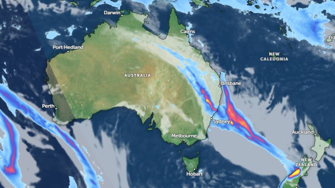
Meteorologist Sarah Scully noted that more heavy rainfalls were possible as a cloud band moves across the country.
According to Ms. Scully, the low will continue to move eastwards on Saturday and will affect southeast Queensland. She noted that the low would begin developing along NSW’s coast on Saturday night. It was expected to bring heavy rainfalls to the regions of northern NSW and southern Queensland on Sunday.
Although the first cloud band over Western Australia was able to temporarily ease its effects, another rainband is expected to develop and hit the state by Monday. It’s estimated that up to 10mm of rain could fall on parts of the country, which is on top of the already recorded amount this week.
According to Ms. Scully, the weather over the weekend would be “another wet one for eastern parts of NSW”. She noted that the intensity of the rain and the winds would depend on the low’s position and proximity to the coast. If the low remains offshore, the coastal impacts would be less severe, but if it moves closer to the coast, the situation could be upgraded to an East Coast low.
A low is predicted to move toward Tasmania and eastern Australia next week. This low is currently affecting the NSW coast and has prompted wind warnings for the regions such as the Byron, Coffs, Hunter, Sydney, and Illawarra. It’s expected to bring rain to Sydney on Saturday, with the maximum temperature reaching 19.
A flood warning has been issued for the Corra Linn region in Tasmania due to the amount of rainfall that has been recorded over the past 24 hours. The area has received around 20 to 70mm of rain, and the Bureau of Meteorology is monitoring the situation. At 1.95 meters, the river is currently resting near the minor flood level.
In Tasmania, the city of Hobart is expected to experience light winds and a maximum temperature near 13. In Victoria, a flood warning is still in effect for the Seven creeks. In Melbourne, there’s a chance of showers or a few fog patches in the hills.
A marine wind warning has been issued for the waters off the Gold Coast of Queensland. A strong wind warning has also been issued for the regions of South East Carpentaria and North East Carpentaria for Sunday. In Brisbane, it’s cloudy with a chance of rain developing in the morning. The city is expected to experience a maximum temperature of 22 degrees.