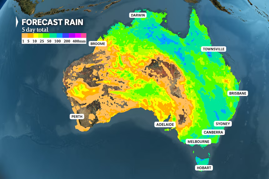
A massive cloudband stretching 4,000 kilometers from the Top End to Tasmania is expected to bring intense downpours in the last days of spring, threatening flash and river flooding across multiple states and territories.
Capital Cities in the Firing Line
Brisbane, Sydney, Canberra, Melbourne, and Hobart are all bracing for impact at some point this week, with the Murray-Darling Basin and tropics facing potential falls in excess of 100 millimeters.
Goodbye Heatwave, Hello Rain
In NSW, the arrival of rain will slowly erode a severe heatwave that’s been responsible for the longest run of hot spring days on record in western Sydney. A slow-moving band of thunderstorms will drench northern and eastern Australia across the coming days, bringing relief from the heat and fire threat.

Severe Thunderstorms on the Horizon
A stream of warm and humid tropical air from the north has already dumped heavy rain on parts of Australia, including record November falls in northern SA and north-west Victoria. The cloudband is gradually moving east, and on Wednesday, rain engulfed Tasmania while severe storms fired up over Victoria and inland NSW.
Melbourne Gets a Soaking
Melbourne picked up 24mm of rain early Wednesday, followed by numerous storm cells in the afternoon that generated a 106 km/h wind gust at Fawkner Beacon and 43mm at Clayton in just 30 minutes.
Sydney, You’re Next
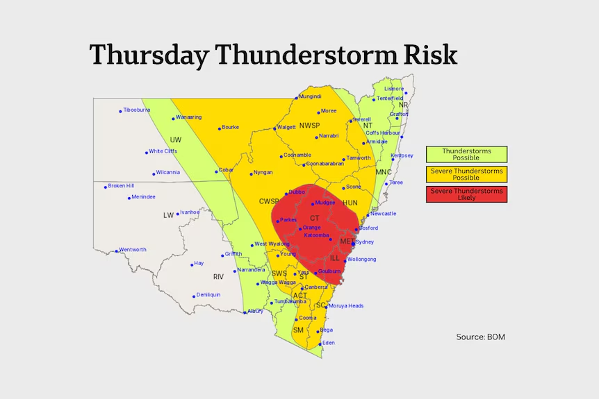
The system will continue its slow march east today, threatening to bring severe thunderstorms in a broad band from the NSW coast to western Queensland. According to the Bureau of Meteorology’s (BOM) storm outlook, Sydney and surrounds are under the highest threat, with severe thunderstorms considered ‘likely’ and capable of bringing flash flooding, large hail, and damaging winds.
How Much Rain Will Fall in Sydney?
High-resolution modeling indicates more than 50mm is possible in just a few hours, a forecast which appears reasonable considering the high atmospheric moisture and the relative slow movement of storms.
Heavy Rain Forecast for the Next Few Days
Typically, a band of storms will clear off the east coast after a day or two, but the current trough will stall over eastern Australia for several days. With a continued supply of tropical moisture, the system will generate further heavy rain across northern and eastern Australia from Friday to Sunday.
Wettest Days Ahead
After today, the likely wettest day for each capital is Friday or Saturday for Sydney, Saturday for Canberra and Melbourne, followed by Brisbane and Hobart on Sunday. The ongoing soaking will boost weekly totals to around 50 to 100mm across a broad swathe of the country — easily Australia’s most widespread rain event since autumn.
Flash Flooding and River Flooding Possible
The intensity of the rain is likely to maintain pockets of short-lived flash flooding into the weekend, and some river flooding is also possible in areas where heavy rain covers a sufficient area. A Flood Watch has already been issued for the Barkley district of the NT, and further warnings could follow for inland NSW, north-east Victoria, and Tasmania.
The Silver Lining: Eroding the Heatwave and Fire Threat
One benefit of the rain will be a reduction of the short-term fire threat across eastern and northern Australia and a slow retraction of a severe heatwave over NSW. The heat peaked on Wednesday when north-westerly winds from the outback lifted temperatures as much as 14 degrees Celsius above average around Sydney.
Muggy Conditions to Prevail
While a cool southerly change won’t arrive across eastern NSW until later next week, thick cloud cover during the coming days will bring brief relief, dropping maximum temperatures to the mid-20s for Friday and Saturday across Sydney. Despite lower maximum temperatures, very high humidity will ensure muggy conditions prevail into the weekend, including a run of nights above 20C.

