

TROPICAL CYCLONE THREAT: Far North Queensland Braces for Catastrophic Floods and Destructive Winds as Low-Pressure System Looms
- Residents in Far North Queensland are on high alert as a low-pressure system threatens to develop into a tropical cyclone, bringing heavy rainfall and potential flooding
- The system is expected to make landfall around the Innisfail area in the next 24 hours, with severe weather building as early as Friday morning
- Communities between Cooktown to Palm Island, including Port Douglas, Cairns, and Innisfail, are under a tropical cyclone watch, with gale force winds and flash flooding expected
- The system could bring rainfall as far south as Mackay and Rockhampton on Saturday, with potential heavy falls around the Wide Bay and Brisbane area on Sunday
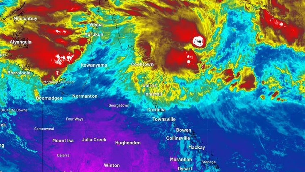
The people of Far North Queensland are bracing for a potentially catastrophic event as a low-pressure system off the coast of Cairns threatens to develop into a tropical cyclone, bringing with it heavy rainfall and potential flooding. The system, named tropical low 29U, is currently sitting about 400km to the northeast of Cairns in the Coral Sea, and is expected to make landfall around the Innisfail area in the next 24 hours.
According to Senior Meteorologist Jonathan How, the Bureau of Meteorology is expecting severe weather to start building as early as Friday morning, with rain and storms already building to the north of Daintree and up towards Cooktown. How warned that regardless of whether the system develops into a tropical cyclone, impacts similar to a category one system – such as heavy rain and damaging winds – are still expected to impact the region.
If the system does develop into a tropical cyclone, it will likely be named Narelle or Owen. Rain is expected to start building from Thursday afternoon and into the evening across the northeast tropical coast as the system draws closer towards the coast, including around Cairns and further south.
Analysis: What This Means for Australia
The potential cyclone poses a significant threat to national security, with the region’s infrastructure and emergency services likely to be stretched to the limit. The impact on local communities cannot be overstated, with flash flooding and gale force winds expected to cause widespread damage and disruption. The economic consequences of the cyclone are also likely to be severe, with the region’s agricultural industry and tourism sector particularly vulnerable.
Security analysts say that the cyclone highlights the need for Australia to improve its disaster preparedness and response, particularly in regional areas. “This event is a wake-up call for Australia,” said one analyst. “We need to make sure that our emergency services are equipped to deal with these types of events, and that our communities are prepared for the worst.”
The cyclone also raises questions about the role of climate change in exacerbating extreme weather events. Industry observers believe that the increased frequency and severity of cyclones and other natural disasters are a direct result of rising global temperatures. “This is a classic example of the kind of extreme weather event that we can expect to see more of in the future,” said one expert. “We need to take action now to reduce our carbon emissions and mitigate the effects of climate change.”
As the cyclone draws closer, residents in the affected areas are being urged to take necessary precautions and stay informed about the latest developments. The Bureau of Meteorology will continue to provide updates as the situation evolves.