

Australia Braces for Torrential Rainfall as Rare Weather Event Strikes: What This Means for the Country’s Already Fractured Climate
- Aussies are on high alert as two rainbands prepare to unleash heavy rainfall across the country, with parts of Victoria, New South Wales, and southwest Queensland set to bear the brunt of the weather event.
- Forecasters warn of accumulated falls of 50 to 100 millimetres over the next seven days, with the Murray-Darling Basin expected to receive the heaviest downpours.
- The unusual weather event is attributed to the Southern Annular Mode (SAM), which has flipped to a strongly positive phase, drawing moisture over Australia from the east and increasing rainfall.
As the rain clouds gather, Australians are preparing for a deluge that will bring much-needed relief to parched regions, but also pose a threat to already saturated areas.
The weather event is a rare occurrence, with the Bureau of Meteorology noting that it’s “unusual for more northern areas to see this much rain at this time of year.”
Parts of Victoria, New South Wales, and southwest Queensland are bracing for the worst, with forecasters warning of heavy rainfall and potential flash flooding.
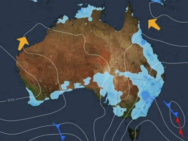
The Murray-Darling Basin, which has been struggling with drought in recent years, is expected to receive the heaviest falls, with accumulated totals reaching up to 100 millimetres over the next seven days.
But what’s behind this unusual weather event? According to Weatherzone, the Southern Annular Mode (SAM) is the culprit.


The SAM is the north-south movement of westerly winds that flow around Antarctica, and it’s currently in a strongly positive phase. This has drawn moisture over Australia from the east, increasing rainfall and leading to the current predictions.
This weather event may seem like a welcome relief, but it’s also a stark reminder of the unpredictable nature of Australia’s climate. Just last week, the Bureau of Meteorology declared Australia’s “strongest ever” El Nino event, despite the strangely wet start to winter.
But meteorologists say that apparent contradiction does not mean El Nino has failed to arrive.
So, what does this mean for Australia?
Analysis: What This Means for Australia The rain may bring some short-term relief, but the long-term consequences are still uncertain.
Security analysts warn that the unpredictable weather patterns could have significant implications for the country’s infrastructure, agriculture, and economy. Law enforcement insiders are also on high alert, warning of potential flash flooding and landslides.
Industry observers believe that the current weather event is just the beginning, with some predictions warning that 2027 could be the hottest year in history.
Stanford climate economist Marshall Burke says that several climate scientists now expect 2027 to become the hottest year on record because of the lagging effects of the developing El Nino.
The World Meteorological Organisation and UK Met Office have both agreed in similar statements.
As Australians prepare for the worst, it’s clear that the country’s climate is more fractured than ever. The Southern Annular Mode may be the driving force behind the current weather event, but it’s just one piece of a much larger puzzle.
As the country struggles to come to terms with its increasingly unpredictable climate, one thing is clear: the need for a comprehensive national strategy to address the challenges of a changing climate has never been more pressing.