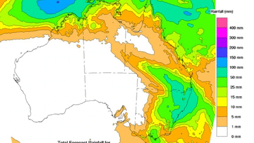
Residents in Queensland should be prepared for possible flash flooding as a weather system that’s moving toward the state could dump up to 200 millimeters of rain on the region. Meteorologist Rob Sharpe of Sky News said that the system could develop into a low-pressure area and produce damaging winds along the east coast.
According to him, the system will most likely form along the east coast over the next couple of days. It could bring strong winds and heavy rain to the region.
⛈️ Today's thunderstorm forecast: Thunderstorms are possible in the southern interior and the far north. They are not expected to be severe, and are most likely in the afternoon and evening. Light showers continuing in eastern districts. Today's warnings: https://t.co/CinugnxqkN pic.twitter.com/3e88W5RZNJ
— Bureau of Meteorology, Queensland (@BOM_Qld) April 1, 2024
The weather system will most likely form near the Queensland and NSW border on Thursday. It could then move toward the coast and bring damaging winds and heavy rain. He said that although there’s a significant chance of flash flooding, it’s not likely to result in a major flood. The weather warning was issued as a trough system that’s moving out of Victoria started to affect the region.
A woman from Victoria had a lucky escape after she got swept away by floodwater after falling into a drainage pipe near Melbourne. The incident occurred at around 8.50 pm in Daylesford. The swift-moving water carried her away for a distance.
Leonie Johnson, a spokesperson for the Victoria Police, said the woman was able to use a metal pole to pull herself out of the drain. According to her, the water reached her neck. The loud noise from the rushing water prevented people from hearing her screams for help.
The woman, who suffered minor bruises and cuts, was able to use the pole to pull herself out of the water. The incident occurred as a band of thunderstorms and heavy rain hit the southeastern part of the country. A severe weather warning was also issued for the eastern and central districts of Victoria due to the weather system.
The Bureau of Meteorology said that the cold front would continue to affect the state’s north east and central regions on Tuesday. It could cause heavy rain and strong winds in the regions. Damaging winds with gusts of up to 90 kilometers per hour are also expected to hit areas such as Warragul, Bright, Morewell and Wonthaggi.
In the southeast, Ferny Creek, which is located about 90 kilometers southeast of Melbourne, received 75 millimeters of rainfall since 9 am on Monday. Other areas such as Malmsbury and the Avalon Station recorded 68 millimeters in less than 24 hours. Meteorologist Steph Miles said residents should be aware of the possibility of flash flooding.
Although the weather system is not expected to cause major riverine flooding, it could cause minor to moderate flooding over roads and other areas. The State Emergency Service warned residents to avoid driving and stay away from areas prone to flash flooding. It also noted that debris and damaged trees could cause dangerous situations.
The weather warnings that were issued for the South West, Wimmera, and Mallee have been canceled. The cold front will then move toward Tasmania, NSW, and Gippsland on Tuesday before hitting Sydney at around noon. It’s expected to continue moving through southern Queensland and northern NSW on Wednesday.
A trough of low pressure is expected to develop off the NSW coast during the week. It’s then expected to move down the coast and bring heavy rain and gale-force winds to parts of Queensland and Tasmania.

