
A weather pattern that will bring unusual weather to parts of Australia is expected to affect the country’s eastern, southern, and central regions.
The Coral Sea’s moisture will interact with a low pressure system near the country, which will then lead to widespread rain and cloud across different regions from Thursday to next week.
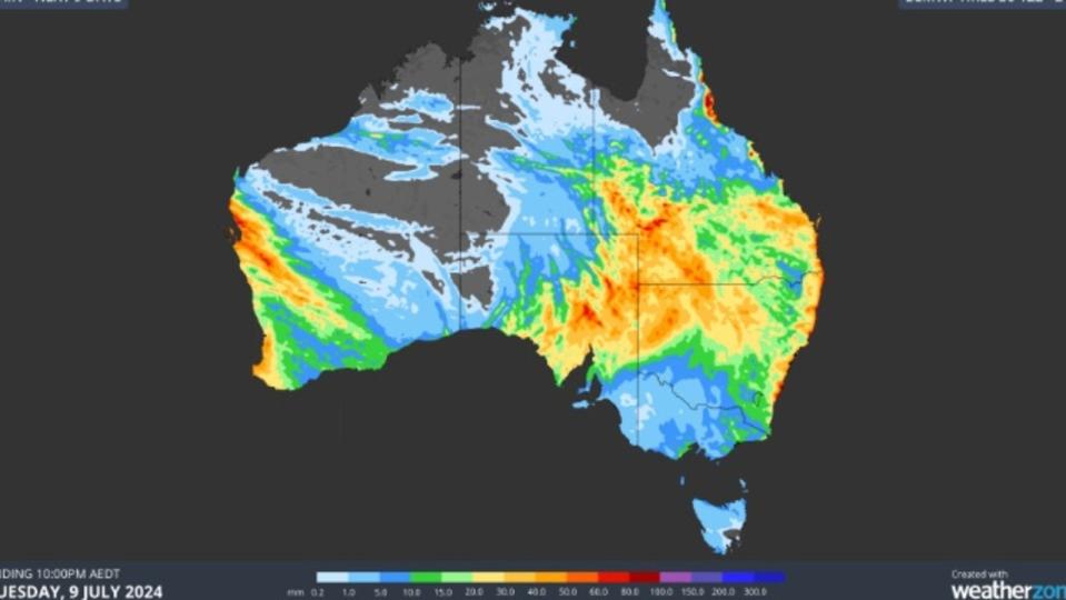
A band of rain and cloud is expected to form over South Australia and Queensland on Thursday and continue to move across the country over the weekend.
It’s likely to bring heavy rainfall to some parts of the country, such as the Murray-Darling Basin and Lake Eyre.
Parts of NSW, Queensland, and South Australia could receive up to 60mm in a short span of time.
The heaviest rainfall is expected to occur in Sydney on Tuesday with up to 15mm. It’s expected to continue to fall throughout the week.
Meanwhile, in Brisbane, up to 20mm is predicted to fall on Tuesday, and the city is likely to get a break from the weather over the weekend.
Cities such as Melbourne, Adelaide, and Hobart are expected to remain dry until showers start to affect them early next week.
While the rain will help fill water storages, it’s also expected to affect the rail and road networks in the country’s remote regions.
According to Ben Domensino, the weather conditions could cause severe weather and flood watches to be issued.
It comes as Australians are getting ready for another Arctic week due to a cold mass moving over the country.
This week, drier and colder air will move across the country. Low temperatures are predicted to occur in most parts of the country.
Melbourne is expected to experience dry and cold weather throughout the week, with maximum temperatures of around 14 degrees Celsius.
In the country’s north, the temperature is expected to drop to around minus 10 degrees.