

Experts are warning of a powerful storm cell that’s set to smash the East Coast, with millions of residents urged to prepare now.
A fast-approaching and intensifying weather event dubbed a “bomb cyclone” is on the doorstep of the NSW coast, with almost the entire State’s eastern coastline under warning from the SES and the NSW Government.
Stay Indoors: SES Warns of Destructive Winds and Intense Rain
From midday, Sydneysiders near the coastline were told to “stay indoors” by the NSW SES. Intense rain has begun in city areas, with regional areas copping an aggressive lashing of rain and wind.
Residents across an 800km stretch of coastline are bracing for severe weather that’s due to dump up to 200mm of rain.
The NSW SES has issued warnings for coastal areas between Bulli and Collaroy, with warnings also in place in areas including Liverpool, Milperra, Penrith, Wallacia, Windsor, North Richmond, and Camden.
Flash flooding is a high risk throughout the East Coast, where heavy rain could cut roads without warning.
Rapid Rain Bursts and Destructive Winds
The system stretches far beyond Greater Sydney, with residents from Bega on the NSW south coast to Coffs Harbour on the north being warned of “rapid” rain bursts.
The BOM has warned of 120mm falling in just six hours in parts of Sydney and the Illawarra, and has told coastline residents to brace for 125km/h winds.
Safety Advice: Stay Away from Floodwater
Emergency services are reminding Australians not to drive, walk, swim, or play in floodwater. People should stay away from flooded drains, rivers, streams, and waterways.
The NSW SES has advised residents to stay indoors due to damaging winds and intense rain.
Bomb Cyclone Brings Travel Chaos
As the ‘bomb cyclone’ weather front ramps up, safety officials have forced Sydney Airport to scale back to one operational runway amid flight cancellation chaos.
Millions of residents are being affected by the massive storm front that is hammering large areas of the east coast.
Airservices Australia has enacted single runway operations at Sydney Airport due to strong south-westerly winds, adhering to international safety regulations for runway usage amid inclement weather.
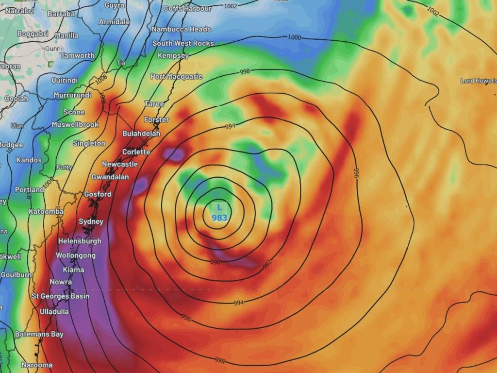
What is a Bomb Cyclone?
Dubbed a “bomb cyclone,” the system is technically known as bombogenesis, which is a rapidly developing storm that forms when atmospheric pressure drops sharply over a short period, creating an unstable air mass.
This particular system is forecast to drop between 22 and 24 hectopascals per day, easily surpassing the bombogenesis threshold.
The result? Torrential rain, destructive winds, and dangerous surf conditions across much of NSW.
The Bureau’s Community Information Lead, Angus Hines, said that the current event is shaping to bring most of the rainfall south, but warned it could take a subtle shift to bring some heavier rain into the mid-north coast.