

A powerful and rare storm is wreaking havoc on Australia’s east coast, leaving around 30,000 customers without power and forcing evacuations in several areas.
The storm, described as a “bomb cyclone,” has brought destructive winds and intense rainfall to the central and south NSW coasts.
Heavy Rainfall and Damaging Winds Cause Chaos
Residents in Jervis Bay, Ulladulla, and Batemans Bay have been warned to stay indoors due to the heavy rainfall and damaging winds.
Meanwhile, people in Burrill Lake have been urged to evacuate immediately due to “dangerous flooding.” In Sanctuary Point, residents have been advised to seek higher ground in sturdy buildings as the situation becomes increasingly dire.
Coastline Under Siege: Wild Seas and Eroded Sand Dunes
The storm has already forced evacuations at Wamberal Beach, where homes are teetering on eroded sand dunes.
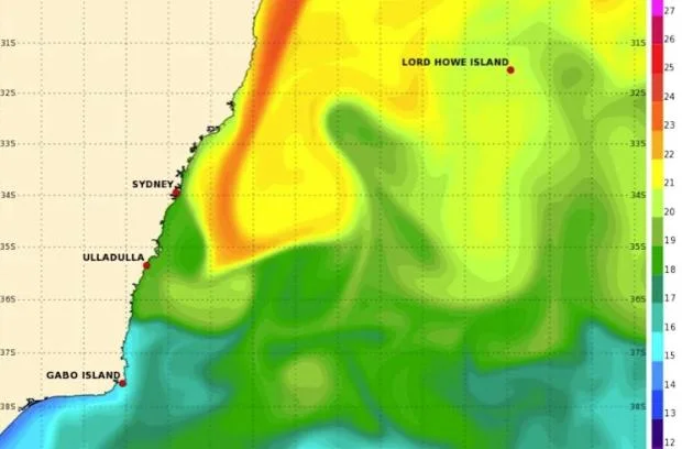
The Bureau of Meteorology has predicted another low-pressure system to enter the storm’s path, which will intensify the winds and rain across the south coast. Senior meteorologist Jonathan
How explained, “We’re expecting another low-pressure system to interact with the first one, which will reinforce the winds and rain across the south coast.”
A Rare and Intense Weather Phenomenon
The storm is a rare example of the Fujiwhara effect, where two low-pressure systems interact with each other. Weather expert Andrew Dowdy described it as “very rare to see two east coast lows spiralling around each other like this.”
The system extends about five kilometers into the sky, making it a significant and intense weather event.
Responding to the Crisis: SES and Transport Disruptions
The NSW SES has responded to over 1,300 incidents, including two flood rescues. The storm has also impacted transport, with commuters urged to avoid non-essential travel across the rail network.
Severe weather warnings have been issued from Queensland’s Lockyer Valley to Bega on NSW’s south coast.
Widespread Damage and Flooding: What to Expect
Wind gusts in the NSW Illawarra region are expected to exceed 125km/h, with isolated rainfall of up to 120 millimeters in six hours threatening to cause flash flooding in Wollongong and surrounding areas.
The storm has already brought significant rainfall to multiple areas south of Wollongong, with Ulladulla receiving almost 100mm of rain in just nine hours.
There is also a chance that Warragamba Dam could spill, threatening flooding in the Hawkesbury-Nepean catchment.
Air Travel Disruptions and Coastal Erosion
Dozens of flights were cancelled at Sydney Airport, while hundreds were delayed. The storm has also taken a toll on coastal areas, with beaches being heavily affected by wind gusts and swells.
Ryan Lloyd, manager of Dunleith Tourist Park, described the scene as “pretty wild” and “a bit scary for homeowners too.” The strong winds are causing more concern than the rain, with tree branches and limbs falling everywhere.
The Road to Recovery: A Long and Difficult Journey
As the storm continues to rage on, residents are bracing themselves for the worst. The cleanup efforts will be massive, and it may take days or even weeks to recover from the devastation.
For now, it’s a waiting game, with residents advised to stay safe and indoors until the storm passes.