

Flash Flood Chaos: ‘Wall of Water’ Hits Gold Coast as 200mm of Rain Brings Widespread Destruction
- Gold Coast hit by intense deluge, with some areas receiving over 300mm of rain in just a few hours
- Motorists rescued from rising waters as roads and low-lying areas inundated
- Police warn drivers not to enter floodwaters after multiple incidents across Fraser Coast and North Burnett regions
- Flash flood warning remains in place for parts of Queensland and northern New South Wales
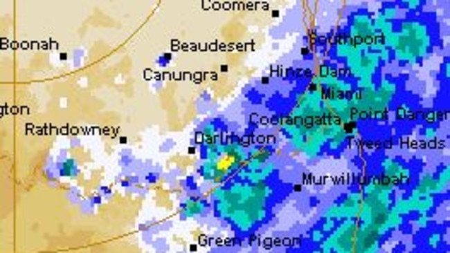
The Gold Coast was transformed into a disaster zone on Saturday morning as a “wall of water” brought widespread destruction and chaos to the region. A staggering 200mm of rain fell in just a few hours, catching out drivers and leaving roads and low-lying areas inundated.
The intense deluge sparked a flash flood warning for parts of Queensland and northern New South Wales, with authorities warning of further heavy rainfall and potential flash flooding in the coming days. The Gold Coast’s backwaters recorded the heaviest falls, with some areas around Springbrook and Narang receiving close to 300mm in a very short period of time.
The heavy rainfall caused lakes to overflow and causeways to burst their banks, in some cases for the first time in eight months. Run-off from the heavy rain flowed out through coastal bars, creating murky water and hazardous surf conditions. Despite the intensity of the downpour, the parched ground was able to absorb much of the rainfall, allowing water to drain away relatively quickly.
However, the authorities are warning that the danger is far from over. The weather system, triggered by a hot air mass colliding with a trough, has now shifted further north, putting the Sunshine Coast and the Wide Bay Burnett region, including areas around Hervey Bay, in the firing line. Forecasters are predicting 20 to 30mm across those regions on Saturday, with the Sunshine Coast potentially receiving up to 45mm on Sunday.
Further north, scattered thunderstorms are expected to redevelop through parts of central and north Queensland, with locally heavy falls possible around Townsville and surrounding districts. Authorities warn that any slow-moving storms could quickly lead to flash flooding, particularly in low-lying areas and along already swollen waterways.
“Analysis: What This Means for Australia
The flash flooding on the Gold Coast serves as a stark reminder of the devastating impact of extreme weather events on our communities. The incident highlights the need for improved infrastructure and emergency response systems to mitigate the effects of natural disasters. As the country continues to grapple with the challenges of climate change, it is essential that we invest in resilience and preparedness measures to protect our citizens and our economy.
Security analysts say that the frequency and severity of extreme weather events are increasingly putting a strain on emergency services and infrastructure, stretching resources to the breaking point. Law enforcement insiders warn that the disruption caused by natural disasters can also create an environment conducive to criminal activity, such as looting and fraud.
Industry observers believe that the economic costs of extreme weather events are often underestimated, with the impact on local businesses and tourism likely to be significant. As the country looks to rebuild and recover, it is essential that we take a long-term view and invest in sustainable infrastructure and climate-resilient planning.
With the weather system expected to remain unsettled into Sunday, authorities are urging residents to stay vigilant and follow evacuation orders. The Bureau of Meteorology (BOM) says conditions will remain unsettled into Sunday, with further showers and thunderstorms possible across south-east Queensland and northern New South Wales before the system gradually weakens.