

Monster Cyclone Maila: Australia on High Alert as Category 5 Storm Looms Over the Solomon Sea
- A powerful category 5 cyclone is barreling towards the Queensland coast, sparking widespread anxiety and uncertainty among residents and forecasters alike.
- Severe Tropical Cyclone Maila has intensified with wind gusts of up to 280km/h, threatening heavy rain, strong winds, and rough seas.
- Conflicting forecast models have left experts scrambling to predict the storm’s trajectory, with some predicting a direct hit on the Far North Queensland coast.
- Residents are advised to seek higher ground and stay away from the edge of the sea as the cyclone threat passes.
The slow-moving giant, currently lingering over the Solomon Sea, has been causing concern for over 1,000km away in Australia, as popular climate models used by meteorologists spit out conflicting data.
A popular American forecast model, JTWC, shows the system crossing the coast in a similar far north Cape York Peninsula location as cyclone Narelle last month.
However, a European forecast model has Maila passing much closer to Cairns and at a much higher strength.
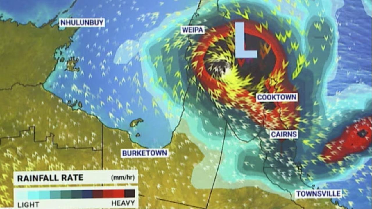
According to BOM senior meteorologist Harry Clark, the cyclone has been very slow moving over the last 24 hours, but did have a bit of a burst of intensification yesterday and overnight, which got it to category 5.
Clark said there are some signs the system may slowly begin to weaken as it makes its way west.


“When we look at the next 24 hours, and indeed the next few days, what we’re expecting to start seeing from later today is that system slowly shifting southwestward and dropping down in intensity very slowly,” he said.
Maila is likely to be a category 4 system by Thursday, before being downgraded again on Friday to a category 3, however, it is still likely to pack a punch as it sideswipes Papua New Guinea before making its way to the Queensland coastline.
The PNG national weather service has warned residents to stay away from the edge of the sea and seek higher ground until the cyclone threat passes.
A cyclone warning is current for Milne Bay Province, and the coastal and island communities of Woodlark, Sudet, Misima, Rossel Islands, and Bougainville. Clark said that in terms of where Maila will arrive in Australia, there still remains a very high degree of uncertainty.
“Model scenarios have it all the way up from Lockhart River down to, in some cases, Cairns.
So at this stage, we can’t be overly specific about where, but Far North Queensland and particularly the areas north around Cairns are looking as the most likely areas.”
Clark explained that Maila’s steering influences are weak, with the system expected to remain slow-moving in the Solomon Sea and well away from the Queensland coast during the next few days.
“Tropical cyclones move based on the winds that steer them, and those winds are generally in the mid-levels of the atmosphere,” he said. “If you have a big easterly broad flow, your system will move to the west.
In this case, the winds in the mid-levels of the atmosphere are quite weak and the steering influences are not really great at all.”
Clark said that once the winds start moving the cyclone west, forecasters will begin to see the direction Maila will take. “We are relatively confident in that movement to the southwest, once it gets going, that it will likely continue,” he said.
“Given it’s so far away, any slight change in the angle of that southward movement has a fairly large implication for the area it moves on to on the Queensland coast eventually.”
Analysis: What This Means for Australia
The looming threat of Cyclone Maila has significant implications for Australia’s national security and public safety. With the storm’s trajectory still uncertain, residents in Far North Queensland are advised to remain vigilant and take necessary precautions.
The Australian Government’s emergency services are on high alert, with evacuation plans in place in the event of a direct hit.
Security analysts say that the slow-moving nature of the cyclone poses a significant challenge for emergency responders, who must be prepared to respond to a range of scenarios.
“The uncertainty surrounding the storm’s trajectory makes it difficult to predict the exact impact on Australian communities,” said one analyst. “However, it’s clear that the storm has the potential to cause significant damage and disruption, and emergency responders must be prepared to respond accordingly.”
Law enforcement insiders warn that the storm’s impact on the Queensland coast could also lead to an increase in crime, as looters and opportunistic thieves take advantage of the chaos.
“We’re urging residents to remain vigilant and report any suspicious activity to the authorities,” said one insider.
Industry observers believe that the storm’s impact on the Australian economy could be significant, particularly in the tourism and agriculture sectors. “The storm’s timing couldn’t be worse, with the peak tourist season just around the corner,” said one observer.
“The damage to infrastructure and crops could have a lasting impact on the local economy.”