

Tropical Terror: Category Five Cyclone Narelle Bears Down on North Queensland, Bringing 250km/h Winds and Flash Flooding
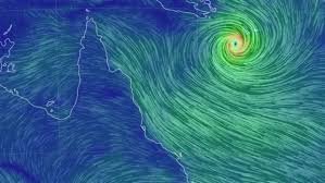
- North Queensland braces for its first category five cyclone in over a century, with Cyclone Narelle expected to make landfall near Coen on Friday morning
- Winds of over 250km/h and heavy rainfall are forecast, with flash flooding and widespread damage expected in the region
- Premier David Crisafulli warns of “widespread damage” and urges residents to take the storm seriously, with some areas already evacuating
The small town of Coen, with a population of just 400, is directly in the path of Cyclone Narelle, which is expected to bring winds of over 250km/h and heavy rainfall when it makes landfall on Friday morning.
The category five system is the first of its kind to hit the region in over 100 years, with the last one occurring in 1899, when a cyclone killed 300 pearl divers.
The Bureau of Meteorology has forecast that Narelle will land between Lockhart River and Cape Melville, before moving over the Cape York peninsula and weakening to a category two.
However, it is expected to strengthen again to a category three before impacting the eastern Northern Territory from late Saturday.
The cyclone is expected to bring heavy rainfall, which may cause flash flooding, between Cape Melville and Cape Tribulation, extending north and inland to areas west of Coen on Friday.


Locally intense rainfall is also forecast for the area around Lockhart River, Cape Flattery, Pormpuraaw, and Weipa.
The high tides also pose a risk, with large waves potentially causing flooding in low-lying coastal areas between Coen and Cape Tribulation. “There is a small risk that tides may approach the highest tide of the year during Friday,” the bureau warns.
Authorities have urged residents to take the storm seriously, with Premier David Crisafulli warning of “widespread damage” and urging many to evacuate earlier. However, with the storm now just hours away, it’s too late for many to leave.
In Cooktown, boaties prepared to spend the night on board vessels to ensure things are tied down, while locals in the area are bracing themselves for another day of wild weather in north Queensland.
“We’ve been here too long and seen too much,” one local said.
But authorities are warning that this storm is different. “It is a rare event.
It’s a large event, and we’re asking people to take it seriously,” Crisafulli said.
Analysis: What This Means for Australia
This category five cyclone has significant implications for national security and public safety in north Queensland.
The widespread damage and flash flooding expected to occur will not only affect local communities but also have a broader impact on the region’s infrastructure and economy.
The fact that this is the first category five cyclone to hit the region in over 100 years highlights the importance of preparedness and emergency response.
Security analysts say that the storm’s impact on the region’s infrastructure will be significant, with the potential for widespread power outages and damage to critical infrastructure.
Law enforcement insiders warn that the storm may also lead to an increase in looting and other criminal activity in the aftermath.
Industry observers believe that the storm will have a significant impact on the region’s economy, with the tourism industry likely to be particularly hard hit. The fact that tourist locations are already battening down the hatches and evacuating staff suggests that the economic impact will be felt for some time.
As the storm bears down on north Queensland, one thing is clear: this is not a storm to be taken lightly. With its sheer intensity and potential for widespread damage, Cyclone Narelle is a serious threat to the region and its people.