

Weather Chaos Grips Australia: Cyclone Threatens Queensland as Heatwave Brings Bushfire Warnings to Southeast
- Far North Queensland on high alert for tropical cyclone, with flash-flooding warnings issued for already saturated areas
- Extreme heatwave conditions to continue in southeastern states, with temperatures forecast to reach 46C in some areas
- Bushfire warnings issued for parts of Victoria and Western Australia, with fires already burning in some areas
Australia is bracing for a wild ride as a tropical cyclone threatens to bring heavy rain and damaging winds to Far North Queensland, while extreme heatwave conditions continue to grip the southeastern states.
In the north, a tropical low is developing off the coast of Queensland, with a moderate chance of it becoming a cyclone by Thursday afternoon. If it does, it will be named Tropical Cyclone Koji. Meteorologist Helen Reid warned that the system is expected to gradually move west or southwest towards the northeast Queensland coast late this week, likely crossing the coast on Friday or Saturday.
“This low is forecast to spend the next few days over warm ocean waters well off shore of the Queensland coast drawing in moisture and energy and slowly strengthening,” Reid said. “Heavy rainfall is forecast to develop during Friday and continue into Saturday, with six-hourly rainfall totals between 100mm to 150mm likely, and isolated falls in excess of 200mm possible.”
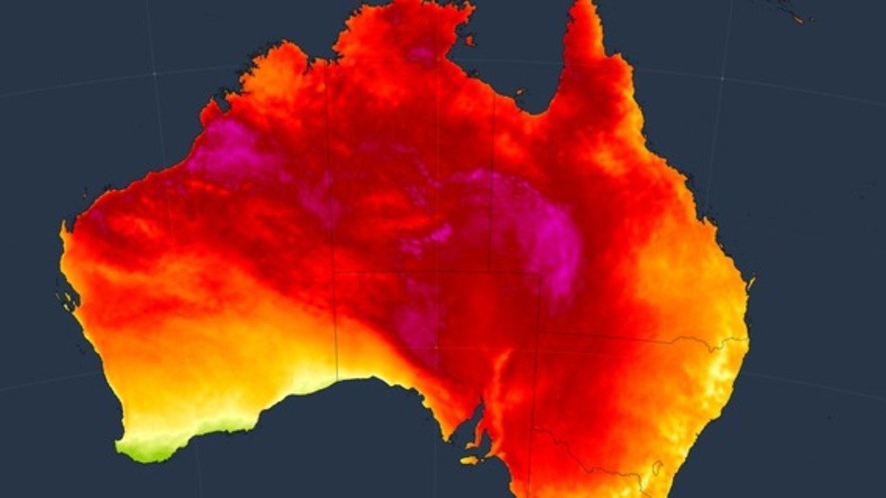
Meanwhile, in the southeastern states, extreme heatwave conditions are continuing, with temperatures forecast to reach 46C in some areas. “We’re likely to see sweltering conditions continuing across inland parts of southeast Australia hitting the mid 40C, if not 46C or 47C, across parts of eastern South Australia, northern Victoria and southwest NSW,” Reid said.
Bushfire warnings have been issued for parts of Victoria and Western Australia, with fires already burning in some areas. Emergency warnings are still in place for fires that are continuing to burn in Western Australia, and evacuation alerts have been issued for parts of Victoria.


The heatwave comes just weeks after parts of Tasmania woke to snow on Christmas morning, highlighting the extreme weather fluctuations that Australia is experiencing. A reprieve is on the way, with a cooler change due to reach much of the southern coast areas of Australia on Friday afternoon and evening.
However, some parts of the east coast will still be battling the heat, with Sydney city expected to reach 42C on Saturday before the cooler change arrives in the evening. High to extreme fire dangers are forecast for much of southeastern Australia, with the worst fire danger day expected on Friday due to hot, dry and windy conditions.
Tasmania has not escaped the heatwave conditions, with severe warnings current for the North East, East Coast, Central North, Midlands and North West Coast. An extreme heatwave warning has also been issued for the Furneaux Islands.
While a fine and sunny day is forecast for Perth on Thursday, with a high of 28C, severe heatwave conditions are continuing in the north of the state with the Pilbara, Gascoyne, Goldfields, North Interior and South Interior all affected. Tropical Cyclone Jenna is weakening over the Indian Ocean and tracking away from the Cocos (Keeling) Islands.
Darwin is experiencing showers and storms with a high of 32C on Thursday, with hot weather for the interior of the state. Alice Springs is set to hit a high of 42C with heatwave conditions still affecting the region. Severe heatwave conditions are expected to ease through the south over the weekend, but continue to develop through the northwest.